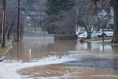
People living along Fourpole Creek in Huntington soon will have something they have needed for 30 years or more �����Ƶ� a system to alert them that flooding is imminent.
By July 1, a stream gauge is to be installed in Fourpole Creek in the Green Valley Road area to give Huntington residents a one-hour notice of flooding. It will be a Doppler radar stream gauge in collaboration with the state, Cabell County 911 Director Nazim Abbess II said.
�����Ƶ�It is our hope that this will give them an early warning system that when the creek is to the flood stage, we�����Ƶ�ll send out an alert and say, �����Ƶ�Hey, the creek is in flood stage here at this location,�����Ƶ������Ƶ� Abbess told The Herald-Dispatch reporter Destiney Dingess.
Abbess said a spot was identified during the May 2022 flood that when the water reaches the area, officials and residents have about an hour before it reaches Enslow Park. The gauge will be tied into the state of West Virginia Emergency Management Division (�����ƵEMD) IFLOWS rain gauges and the USGS stream gauges system. �����ƵEMD will monitor the stream gauge. Cabell officials will be able to receive the same information, Abbess said.
At present, the CASS system is manually driven, meaning someone has to physically see the water rise or a resident has to report it to Cabell County 911 before an alert is sent out by an individual, Abbess said. While he is not as worried about water rising during the day since safety officials are out keeping an eye on the water, Abbess said he worries about the water rising during the night when very few people are awake, as happened when Fourpole rose in February.
An alert system is good, and it can be put in place quickly. Preventing flooding is a different matter.
Fourpole Creek is long and meandering. In the past three or four decades, its watershed has changed in ways that inhibit the absorption of runoff from heavy rains and instead funnels it into residential areas, including those in Huntington. Part of the floodplain has been filled in to support commercial and residential development. Forested areas have been cleared and paved over for roads, schools and other uses.
In some places, trees have fallen and clog the channel during high water. In Huntington, old, small bridges can restrict the flow of floodwater.
In addition to all that, there is no one governing authority at the local level �����Ƶ� county or municipal �����Ƶ� that can regulate the entire watershed.
A long-term solution to Fourpole flooding is a long way off, assuming there is one. So far no one is willing to remove the changes in the watershed that may contribute to runoff that becomes floodwater. Other conditions in the watershed will need to be altered �����Ƶ� a series of expensive propositions that likely will cause local opposition.
At least the new warning system will give people along the most flood-prone areas of Fourpole time to prepare no matter the time of day. It�����Ƶ�s a start.
Keep it Clean. Please avoid obscene, vulgar, lewd,
racist or sexually-oriented language. PLEASE TURN OFF YOUR CAPS LOCK. Don't Threaten. Threats of harming another
person will not be tolerated. Be Truthful. Don't knowingly lie about anyone
or anything. Be Nice. No racism, sexism or any sort of -ism
that is degrading to another person. Be Proactive. Use the 'Report' link on
each comment to let us know of abusive posts. Share with Us. We'd love to hear eyewitness
accounts, the history behind an article.
Recommended for you
If you're interested in submitting a Letter to the Editor, click here.


